


 LIMITED TIME OFFER!

The 2015-2016 Winter Weather Forecast
Clay Vaughan | 4th Aug 2015
Here at eheat, we are all about the weather and helping you prepare for it. So in our research and study, we have found that long range climate models are showing a sea surface temperature anomaly prognosis that could be leading to another cold and snowy winter, particularly along the East coast of the U.S.

|
| Climate Prediction Center |
The graphic above shows relatively intense sea surface temperature anomalies from seven different long range models, which are valid for November 2015. There are a few areas of interest on the chart above. We'll begin in the Gulf of Alaska and work our way south from there.
In the Gulf of Alaska, the ensemble mean of models tells us that the warm pool we have seen the last two winters will only continue for a third consecutive winter, with temperature anomalies definitively above normal in that area.
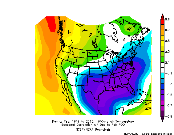
|
| ESRL |
So what does that warm pool in the Gulf of Alaska mean for us? The chart above shows the correlation between the Pacific Decadal Oscillation, and temperatures in the United States in the winter. For example, if the Pacific Decadal Oscillation (PDO) were negative (which would be signified by cold waters in the Gulf of Alaska), the negative correlation area over the South and East US tells us temperatures would be warm there. Similarly, temperatures would be colder than normal in the positive correlation area.
As we head into the coming winter, it is expected that the pool of warm waters over the Gulf of Alaska will persist, as climate models above suggest. Using our chart from the ESRL, a positive PDO correlates to below-normal temperatures in the South and East, and warmer than normal temperatures in the West. This is not a good preliminary outlook for those in the Southwest undergoing a devastating drought.The other key item we see on this prognosis is a large swath of above-normal sea surface temperatures along the Equator in the Pacific. This is the El Nino phenomenon.

|
| NCSU |
In a typical El Nino winter, warmer than normal conditions will prevail along the south Alaskan shore into western Canada and the Pacific Northwest. Wetter and cooler than normal conditions are then favored in the Southwest, South-central, and Southeast United States, all the way up along the East Coast, though that area is not depicted with those anomalies. Drier conditions then prevail in the Ohio Valley.
Last season, there was talk of an El Nino brewing for the winter, which it did end up doing, but very late in the season. Part of the reason the El Nino didn't evolve as eagerly as forecasted was likely how Equatorial Pacific waters were rather cool in the spring before last winter, which is not a good breeding ground for the El Nino. This spring, however, we are already under a weak El Nino, and climate models expect that to intensify as we push into the fall. If this happens, the forecast for next winter could once again be one of snow and chilly weather for the East.
To summarize:
- Climate models are indicating portions of the South and East coast will another cold and snowy/wet winter in 2015-2016.
(special thanks to Paul Dorian from Vencore for the bulk of this information)